Sunday, February 14, 2016

Kaziranga

The star attraction at Kaziranaga National Park: The Indian one horned rhino. The park is said to contain about two thirds of the world's population of the rare beast, so many that it's virtually impossible to visit Kaziranga and not see dozens of them

One of the very first places I ever went to in India, all the way back in January 2009, was Kaziranga National Park. By now, as part of University of Delaware study abroad groups, while leading my own trips, or while travelling with members of my family, I've visited the park somewhere in the vicinity of six times. That may sound like overkill, but, believe me, it's not. I've found that my enthusiasm for the place has only grown over time. 

Thursday, October 1, 2015

The Undiscovered Living Root Bridges of Meghalaya Part 4: Living Root Ladders and other uses for living root architecture


Heavy metal living root ladder near the mid-sized Khasi village of Pongtung

First off, for more information on living root architecture, go to The Undiscovered Living Root Bridges of Meghalaya Part 1: Bridges of the Umngot River Basin for living root bridges in the Jaintia Hills, The Undiscovered Living Root Bridges of Meghalaya Part 2: Bridges near Pynursla for information on the area with the highest concentration of living root architecture, and The Undiscovered Living Root Bridges of Meghalaya Part 3: Bridges of the 12 villages for some of the most remote known living root bridges.

Also, for information on a trip that I'll be leading to some of these incredible structures, go to Northeast India Explorer Itinerary 

Thursday, September 24, 2015

The Undiscovered Living Root Bridges of Meghalaya Part 3: Bridges of the 12 Villages

My friend Roy on a spectacular, never before visited living root bridge near the village of Kongthong, in the heart of a region called the Katarshnong, or 12 villages

First off, for more information on obscure living root bridges, go to: The Undiscovered Living Root Bridges of Meghalaya Part 1, covering the living root bridges of the Dawki region, and The Undiscovered Living Root Bridges of Meghalaya Part 2, which covers the area with the highest (known) density of living root architecture, the hills and valleys surrounding the small town of Pynursla.


Monday, September 14, 2015

The Undiscovered Living Root Bridges of Meghalaya Part 2: Bridges Near Pynursla


Jungle Man John Cena and friend cling to roots with the longest known living root bridge in the background

First, for more info on obscure living root bridges, go to: The Undiscovered Living Root Bridges of Meghalaya Part 1: Bridges of the Umngot River basin

Also, for info on a trip I'll be leading to the amazing place in the picture above (along with tons of other incredible places!), go to: Northeast India Explorer Itinerary

Wednesday, September 2, 2015

The Undiscovered Living Root Bridges of Meghalaya Part 1: Bridges of The Umngot River Basin


The Great Bridge of Kudeng Rim...photos don't do it justice. 

This is the first of four posts on the living root architecture of Meghalaya. The other three are coming soon!


In February of 2015, I set off alone into some of the most remote parts of the state of Meghalaya. My aim was to locate previously undiscovered, or little known, examples of living root architecture. In this, I was vastly more successful than I ever could have hoped. As I figure it, over the course of a one month long hike from the village of Shnongpdeng to the town of Sohra, I reached over fifty examples of living root structures. While by far the most numerous of these were living root bridges, I also managed to locate a number of other varieties of living architecture, including living root ladders, observation platforms, retaining walls, and also a number of structures which served several of these purposes at once.

Thursday, August 27, 2015

10 More things to see in Delhi that are not in Lonely Planet

A corridor in Khirki Masjid, one of the most atmospheric historical places in Delhi, and also one of the city's most under appreciated major monuments

For the first half of my write up on what Lonely Planet missed in Delhi, go to: http://evenfewergoats.blogspot.com/2014/12/10-things-to-see-in-delhi-that-are-not.html 

Starting right in the middle of South Delhi, here are ten more interesting places to visit in that sprawling metropolis which are not included in the most recent editions of Lonely Planet.

Thursday, July 16, 2015

Hyderabad (V2)

The spectacular chandeliers of the Kilawat Mubarak, the durbar hall of the Chowmahalla palace, along with the royal seat of the Nizams of Hyderabad.

And now for something completely different. In October of last year, I spent a little over two weeks exploring the fantastic state of Karnataka (and a little bit of Andhra Pradesh), in southern India. Despite the fact that Northeast India is perhaps the most inaccessible part of the county, by an odd set of circumstances it's the part that I now know best. But I had never been south of Agra (with the exception of the Andaman Islands which are something else entirely). This was my first foray into the south, and hopefully there will be many more to come. 

Wednesday, July 8, 2015

The Exuberant Rickshaws of Bangladesh

A common sight in Dhaka

In May, 2015, I traveled across Bangladesh, crossing the border from West Bengal and reentering Indian via Dawki in Meghalaya. The country left many impressions, but one of the strongest was made by its cycle rickshaws, which were decorated as brightly, colorfully, and crazily as possible. 

Monday, December 1, 2014

10 Things to see in Delhi that are not in Lonely Planet

The largely forgotten tomb of Roshanara, world's away from the better known parts of Delhi.

For the second half of this list, please go to: 10 more things to see in Delhi that are not in Lonely Planet

First off, let me say that I am in no way trying to disparage Lonely Planet. I would be a massive hypocrite if I did. I have found their titles incredibly useful over my years travelling in India. I think I've all but memorized large sections of text from several of their guidebooks (particularly their 2011 edition of Rajasthan, Delhi, and Agra). In short, having a Lonely Planet can really make travelling easier.

That being said, no guidebook, no matter how well-researched, is truly comprehensive. For example, the two most recent editions of Lonely Planet guidebooks dealing with Delhi, the one mentioned above and their 2013 pan-Indian title, both devote nearly 50 pages to the city, and yet vast swathes of Delhi's history, landscape, and cultural heritage are left out. 

This isn't the staff at Lonely Planet being derelict in their duty (except in those few instances where their information is incorrect, which I'll get to in my next post). Rather, it's a symptom of Delhi's long and exceedingly complex history. The city's unique position as the capitol of (as I figure it) eight different kingdoms and empires over the course of the last 1500 years has left Delhi with an almost mind-boggling assortment of historical sites. Including all of these in a single volume would require a book at least as large as the entire Lonely Planet India title. Every single tomb, mosque, and obscure complex of ruins can't have an entry...


Tuesday, September 9, 2014

Modhera

Looking out through the entrance of the Guda Mandap, or Sanctum Sanctorum, of the Modhera Sun Temple.

The Sun Temple of Modhera is, like Rani ki Vav, one of the few remaining architectural splendors left behind by the 10th to 13th century Solanki Dynasty of Gujarat. I made a brief visit here while in transit between Patan and Ahmadabad, spending only around two and half hours in the area (and much of that time was consumed having tea at the Modhera bus stand with a shady though not entirely disagreeable member of the town council trying and not succeeding to hustle me out of  my Swiss army knife...he seemed to be hoping that plying me with free Chai would have the same effect as free alcohol. Anyway.) The stop-off made for a long day of travelling, but it was more than worth it. 

Wednesday, August 13, 2014

Rani ki Vav

Rani ki vav, arguably the world's most impressive stepwell. 

Simply put, Rani ki vav, or "The Queen's Stepwell," in the little northern Gujarati town of Patan, is one of the foremost man made wonders of India. The stepwell is generally thought to have been built by Queen Udayamati of the Solanki dynasty as a memorial for her deceased husband, Bhimadeva I, in the late 11th century. At the time, the Solankis ruled over much of what we now refer to as the state of Gujarat, and their reign is often viewed as a golden age in the history of the region. 

Friday, May 2, 2014

Agra 7: Itimad-ud-Daulah's Tomb and Chini ka Rauza

The top of the fantastic tomb of Itimad-ud-Daulah, in the very first direct sunlight of the day.

Along the east bank of the Yamuna, across from the Taj, Agra Fort, and the Old City, are the remnants of a long series of Mughal gardens and tomb enclosures. I had hoped, on my last morning in Agra, to take a long walk along the entire riverfront and see most of these, though I wound up pressed for time and was forced to only visit a couple of the highlights: The spectacular tomb of Itimad-Ud-Daulah, and the interesting and unique Chini ka Rauza, or China Tomb.

Saturday, April 26, 2014

Agra 6: The Old City

A late 19th or early 20th century courtyard, somewhere deep in Agra's fascinating old city.

As odd as it may sound, there is a vast and deeply historical part of Agra, India's most heavily touristed city, which is almost entirely ignored by outsiders. This is The Old City, the bustling, incredibly intense, impenetrable seeming region of Agra north of the Red Fort and west of the Yamuna. Here, beginning in the 16th and 17th centuries, were the great mansions of the Mughal elite and the business communities which profited from the Mughal court's ridiculous expenditures (which apparently largely drove the economy of the entire empire.) 

Sunday, April 20, 2014

Agra 5: Not Getting to Firoz Khan's Tomb

Hot action and glamour. Bizarre poster for some American Z grade western that was being shown dubbed into Hindi at local cinema halls in Agra. Don't ask me how the distributors got their hands on this undoubtedly classic film.

South of Agra, on the road that leads towards Gwalior, is the tomb of Firoz Khan, and I have never been there. My abortive attempt at visiting the tomb, quite unexpectedly, turned into the most genuine adventure I had during my time in Agra, and while I wound up with absolutely no nice pictures from my strange misadventure, it was still very much experience worth having. 

Friday, March 28, 2014

Agra 4: Sikandra


Truly excellent carvings on the side of one of the false gateways to the tomb of the Mughal emperor Akbar. The carvings say a great deal about the man, as they show that he did not adhere to a strict interpretation of Islam, which forbids any sort of art depicting humans or animals. It's rather a shame that by Shah-Jahan's time the Mughals had shifted away from incorporating carvings of living things other than plants into their buildings. The quality of the craftsmanship here is extremely high, as it is throughout Akbar's tomb complex. It's interesting to speculate where Akbar's style of architecture would have gone had it outlived him.

Sikandra is an area about 10km West of the Taj Mahal. It's assumed that the name comes from Sikander Lodi of the Delhi Sultanate, who moved his capitol from Delhi to Agra in the 16th century. Why his name was applied to this particular patch of ground, is unclear, as his stronghold was most probably at the location of today's Agra Fort, while there are no Lodi era remains in the immediate vicinity (though the dates of some of the buildings in the area are a matter of controversy).

Monday, March 24, 2014

Agra 3: Roman Catholic Cemetery

The rather splendid late Mughal style tomb of John Hessing, the most prominent mausoleum in Agra's 460 year old Roman Catholic cemetery. The information available about Hessing is vague and often contradictory, but from what I've been able to find, it seems that he was once a soldier in the Dutch East India Company army who fought the British in Ceylon during the fourth Anglo-Dutch war. After the British victory, they took possession of the Holland's territories in India, but Hessing decided to stay in the subcontinent and  find employment as a professional soldier. He entered the service of the Nizam of Hyderabad, and then moved on to serve with the Marathas, fighting as an officer in their army against both other Indian armies and those of the British East India company. In 1799 he assumed command of Agra Fort and held it until his death. The tomb was commissioned by his wife Anne and their family. It is usually said that, like the Taj Mahal, the Tomb of John Hessing was built out of grief at the loss of a loved one. For this reason, and also because Anne Hessing was apparently inspired by the Tomb of Mumtaz Mahal, the Tomb of John Hessing is frequently referred to as the Red Taj. This is rather unfair, as it makes it sound as though Hessing's Tomb is little more than a cheap imitation of the Taj, when in fact it is very much its own mausoleum. The architecture is similar in certain respects, but the design of the tomb is, in the final analysis, just not that much like the Taj.  The building itself, which betrays hardly any European architectural influences, is considered one of the finest European tombs in India. In style, the mausoleum is entirely Mughal, despite the fact that Hessing was a Christian.


Monday, March 17, 2014

Agra 2: Agra Fort

Red sandstone carvings in the Jehangiri Mahal of Agra Fort. 

Because of its proximity to the Taj Mahal, Agra Fort is the second most visited historical site in Agra. The fort is one of the most extensive, and also most intact, collections of Mughal architecture in India. The Delhi Red Fort is similarly spectacular, and may have at one point been just as impressive as the fortified city in Agra, but unfortunately time has not been kind to the fortress in Delhi, which, due to the British clearance of large parts of the compound after their crushing of the Sepoy uprising, is little more than a hollow shell of itself. Nearby Fatehpur Sikri, the short lived capital city of Akbar, also contains a large concentration of the greatest buildings of the Mughal period, but they were all built within a relatively short period of time and all reflect the Indo-Islamic architectural tastes of Akbar's reign. Agra Fort on the other hand contains a mixture of buildings in both the Akbari style and in the later, more austere, style of Shah Jahan. Thus it is perhaps the only place in the world where one can see the very different architectural styles of the Mughal empire's two most prominent builders literally side by side.

Sunday, March 9, 2014

Agra 1: The Taj Mahal


The Taj at dawn. Now there's a picture I bet you've never seen before. Actually, this is maybe the world's single most iconic image, but since the entire tomb complex is oriented around creating this very composition, you mustn't blame me for taking a cliched snap. 

This is the first post in a series I'm going to do on a very intense week long trip I took to Agra in October of 2013. My two main purposes in re-visiting Agra were to go to the places I had not been to before (and there were many), and also to conduct reconnaissance for trips I'm planning to lead. I had been to the Taj Mahal no less than three times previously, yet this was the first time that I had the chance to see it at dawn, so that's where I'll start. 

Monday, February 17, 2014

Meghalaya Monsoon Itinerary

Crossing the Nongthymmai living root root bridge, the longest of all (known) living root bridges, in the monsoon season of 2011. Believe it or not, the whole span is made of rubber tree roots that were trained across that stream over the course of a few decades by local Khasi villagers, making it one of the world's most striking examples of biological architecture. During this trip, we'll be staying in a small village about 45 minutes from here, in a little visited corner of northeast India that's simply abounding in fantastic things to see. 

MEGHALAYA MONSOON TRIP

Here's some information on an itinerary I'm going to be running twice during this year's monsoon season in the northeast Indian state of Meghalaya. Meghalaya receives more rainfall than any other place on the planet, and is home to centuries old living root bridges and one of India's friendliest and most interesting tribal communities: the Khasis. It's a place of stunning beauty, of four thousand foot deep, mist filled canyons, where there's literally a waterfall around every corner, and where the average day's walk involves crossing raging, monsoon-swelled torrents over suspension bridges not much wider than your foot that are strung across rocky chasms......

Sunday, January 26, 2014

An Unknown Living Root Bridge

Tyndrong Bridge 

[Note: All of the spellings of Khasi villages below are merely my idea of how they should be spelled...I don't pretend to have a system, and many of these names I've never seen in writing. I have encountered the spelling "Tynrong" for "Tyndrong" a few times, and that does seem to be the more common version. However, I think for practical purposes, "Tyndrong" is a more useful English rendering of the word, as whenever I've heard it pronounced it definitely contains a rolled "D" sound between the "N" and "R" sounds, and if you were asking directions from some random Khasi in the middle of the jungle, I think you would be more likely to be understood with "Tyndrong" than "Tynrong."]  

A few months back, I decided to go exploring in the rugged jungle canyonlands west of the Khasi village of Nongriat, in a part of the northeast Indian state of Meghalaya which has seen almost nothing in the way of tourism. While on this expedition I discovered, quite accidentally, a living root bridge which I am now reasonably certain was previously unknown to the outside world. It runs across a stream just below the village of Tyndrong, which is about three hours of moderately difficult hiking from the world famous Double Decker living root bridge of Nongriat. Living root bridges are exceptional given that they are among the only forms of architecture that are grown rather than built. Given that there are less than twenty known examples in the world (which are all in the East Khasi Hills of Meghalaya, except for one in Indonesia), finding a new one is no small thing. However, I think that what stumbling upon a new living root bridge primarily indicates is that there are probably many more out there which are unknown to the outside world. There would seem to be a great deal more exploring to be done in the canyonlands of Meghalaya. Of course, saying that the bridge was "undiscovered" would not be true. Locals use it everyday, and presumably have for the past few hundred years. But what is notable is that no word of Tyndrong Bridge had reached people just a few 
villages over. 

Thursday, December 19, 2013

Mehrauli: Qutb Minar Complex

A highly decorated prayer niche. Part of the large mosque next to the Qutb Minar in Mehrauli. This part of the complex dates from the early 13th century, and was constructed by Iltutmish, the second ruler of the Mamluk, or Slave, dynasty of the Delhi Sultanate. This panel displays a variety of different decorative motifs, including two varieties of Arabic calligraphy. The carvings on the row furthest to the right are in an early Arabic script called Kufic, which seems to have developed in the fourth century, well before the advent of Islam. The earliest surviving Korans were written in the Kufic script, and the system of writing was used by a number of groups of central Asian Muslims who were culturally similar to the Mamluks. The carvings on the next row over are fairly stylized representations of leaves and vines, while the third row consists of more Arabic carvings, in this instance in the much later Nashki script. 

My blog posts on Delhi have largely focused on the more obscure, or at least less touristy, places in that vast city. Yet, sometimes, it's good to go back and visit the classic sites. I've already done a blog post on the Mehrauli Archaeological Park, and at some point I'm going to do a post on the interesting things to see in Mehrauli Village, which I visited a few months ago. That being the case, it seemed fitting that I should do a write up on what most people come to see when they travel to Mehrauli, namely, the Qutb Minar and the complex of early Sultanate buildings around it. 

Friday, September 13, 2013

Hampi Pt. 2

The 15 foot tall monolithic Kadalekalu Ganesha statue, in a shrine behind Hemakuta Hill. Carved out of a single granite boulder, this is one of the largest representations of Ganesha in the region. The word Kadalekalu means "Gram" in  the local language, which the statue's belly is thought to resemble. In his hand, Ganesha is holding a rice cake, which he's eating with his trunk. I was surprised that this photo turned out as well as it did, given how little light there was in the shrine.    

The great thing about Hampi is that it offers an almost limitless amount of places to explore. While there are a number of "must see" sites like the Lotus Mahal and the Vittala Temple, there are also a huge number of ruins and natural features in the area which see relatively little traffic.  This post is going to focus on the less visited parts of the ancient capital, along with a few of the major sites that I missed on my first day exploring the ruins of Vijayanagara. As you might expect, here's much more to Hampi than what I've posted here. I think you could spend your whole life studying the area and still not see absolutely everything.


Thursday, July 25, 2013

Anegondi

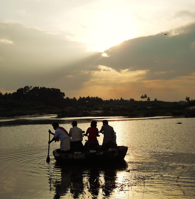
Coracle crossing the Tungabhadra River, late in the afternoon. Coracles have been a means of conveyance in the Hampi area since prehistoric times, and even in the present they seem to have certain advantages over traditional boats. They're cheap, and so lightweight that they can be carried balanced on a person's head like a great big hat. Yet, with such low displacement combined with such a large amount of surface area in contact with the water, they can carry surprisingly heavy loads. The craft in this picture is holding three motorcycles and four people...what must be well over a thousand pounds in a vessel that looked like it weighed less than thirty. Coracles are used quite extensively in the Hampi region, sometimes just for tourist boat rides, but also because, at the moment, there's no bridge that connects Hampi with the settlements just on the other side of the Tungabhadra, such as Anegondi and Virupapur Gaddi. Note the dragonfly flying through the upper righthand corner of the picture.    

The little, sleepy, laid back village of Anegondi (Anegondi meaning something like "elephant enclosure") is situated across the Tungabhadra river from the remains of the city of Vijayanagara. Though the ruins in Anegondi are less spectacular, the village has a longer history than the much more well known and frequented historical site on the opposite side of the river. It is also on the other side of the Tungabhadra that the rocky, central Karnataka boulderlands rise to their most spectacular heights.


Wednesday, July 17, 2013

Hampi Pt. 1

A beautiful maiden with a creeper, on one of the door jams in Vijayanagara's ruined Krishna Temple. 

Combining an entire city's worth of incredible South Indian architectural marvels with one of the subcontinent's grandest landscapes, Hampi is unequivocally one of India's most magnificent historical sites.

Saturday, June 29, 2013

Feroz Shah Kotla

In a chamber under the Feroz Shah Kotla Mosque. 

The ruins of Firozabad, the fifth city of Delhi, stand tucked away next to a giant cricket stadium, just south of the former line of the walls of Old Delhi. It's not on most visitors itineraries, and even people I've know who have been living in Delhi for quite some time haven't gone there. The reason for this is, I think, relatively simple: Firozabad, otherwise known as Firoz Shah Kotla, is not pretty. Rather, it's scary, immensely atmospheric, and is generally considered one of Delhi's primary centers of supernatural activity....It's not for the faint of heart. Visiting the ruins on a Thursday afternoon, when people come from the surrounding area to petition disembodied spirits for favours and forgiveness in dark, dungeon-like chambers in the sad remnants of a once grand, but now almost totally destroyed, 700 year old city, is one of the most intense experiences that Delhi, a city that is nothing if not replete with intense experiences, has to offer. 

Monday, June 24, 2013

A Day Out From Badami

Nataraja, in the Ravana Phadi cave temple in Aihole, flanked by Ganesh. Nataraja is the form of Shiva whose dance of cosmic destruction will obliterate the old universe in preparation for the new. The Ravana Phadi Cave, dating back to the 6th century, is one of the very earliest Chalukyan monuments, predating the cave temples at Badami. Though Chalukyan architecture would develop a great deal between the this period and the 8th century, their skill at sculpting appears to have peaked rather earlier. For my money at least, the very greatest Chalukyan carvings, which certainly include this Nataraja, are in Aihole...Aihole is actually pronounced "Aye-oh-lei," and frankly I wish that whoever decided to render the name into English had gone a more phonetic route...talking about it actually presents exactly the same problem as bringing up the name of the planet Uranus...oh well....

My second day in the Badami area was one of the very best purely travel days I've ever had in India. In the twelve hours I spent on my feet, I wound up visiting roughly three quarters of the core of the ancient Chalukyan Empire (something which I can't say I do every day.) 

Tuesday, June 11, 2013

Badami

Frieze of Varaha, the boar-headed incarnation of Vishnu, holding his consort Bhudevi in one of the cave temples of Badami. The story behind this carving is that the demon Hiranyaksha, the beheaded corpse of whom Varaha is standing on in this depiction, kidnapped the Earth, as personified in Bhudevi, and took her to the bottom of a cosmic ocean, whereupon Vishnu sent his boar incarnation to slay the demon and take her back.

So, this is back in Karnataka, during the trip I took in October of 2012.

For me, visiting Badami was a trip into Terra Incognita: Whereas most of the historical sites that I visited in Karnataka were from a period that I was at least nominally familiar with, the great cave temples and temple architecture of Badami were mostly from a much earlier time, before the advent of Islam in South India. What's more, though I had been to a number of old Hindu sites before, most were in Assam, a place extremely culturally different from Karnataka. 

Tuesday, June 4, 2013

Mehrauli Archaeological Park

The sixteenth century Rajon ki Baoli, or Well of the Masons. Built in the final years of the Delhi Sultanate, it's  Delhi's most ornate step-well, and one of the main attractions at the Mehrauli Archaeological Park.

The Mehrauli Archaeological Park is perhaps Delhi's best kept secret. Containing ruins which, if one counts the foundation of the Hindu Rajput fort which underlies the whole area, date anywhere from the 8th to the 19th century, and encompass virtually the whole history of Islamic Delhi and then some, the park is among the very most fascinating places in the whole city. What's more, it's practically unknown.

Friday, May 24, 2013

Exploring the Abode in the Clouds


My brother crosses the Nongthymmai Living Root Bridge, the longest of all (known) living root bridges, and arguably the most spectacular, in the monsoon season of 2011. Believe it or not, the whole span is made up of nothing but rubber tree roots that were trained across that stream over the course of a few decades by the local Khasi villagers. It is perhaps the world's most amazing example of biological architecture. During this trip that I'm putting together, we'll be staying in a village guesthouse about half an hour away from here, in a little visited corner of northeast India that is simply abounding in fantastic things to see.

Saturday, May 11, 2013

Khirki Masjid

Arches and Pillars in Khirki Masjid, one of the most unusual and atmospheric buildings in Delhi. Constructed during the reign of Firoze Shah Tughlaq, perhaps the Delhi Sultanate's greatest builder, in the 14th century, the building combines design elements from traditional mosques,  Islamic military architecture, and Hindu temples. The result is a mosque like no other.

The Khirki Masjid is bizarre in a number of ways. First off, the vast majority of the world's Mosques are either open air (such the Delhi Jama Masjid), or have huge spacious chambers, so that large congregations can gather. But in the Khirki Masjid, the congregation space is enclosed, with the interior of the building being divided by rows of pillars into a series of narrow arcades, rather after the fashion of many Hindu temples. The Masjid was in fact designed by a recent convert to Islam from Hinduism, which may to certain extent explain it's unorthodox layout. The Masjid is also unusual for its embattled, fortress-like appearance. It certainly does not look like a mosque from the outside, and if I had just stumbled upon it, I would not have guessed that that was the function the building served. Its harsh, rather functional and militaristic style makes the building look more like it was meant to keep people out than to allow them in. 


Sunday, April 28, 2013

Sultan Ghari

The Sultan Ghari, Delhi's first Islamic tomb, and one of it's most obscure monuments. It was built in 1231 for one of the sons of Iltutmish, the third ruler of the Mumluk, or Slave, dynasty of the Delhi Sultanate. The tomb was constructed before most of the trends that are now associated with Indian Islamic funerary architectural came into their own, the result of which being that the design of the tomb is unique among Delhi's monuments.The domed structure in the foreground is a much restored cenotaph for one of Iltutmish's other sons. There were apparently once two cenotaphs on either side of the monument, though the other one no longer exists. 

So, after quite a long while, here's another blogette:

Monday, March 18, 2013

Adilabad

The evil countenance of Adilabad Qila, as far as I can tell Delhi's least visited fort.

Tughlaqabad, the former stronghold of the third dynasty of the Delhi Sultanate  is a truly vast complex of ruins, most of which are rarely visited. Even the area's primary attraction, the citadel of Tughlaqabad Fort, is far from being at the top of the average tourist itinerary. I think that the main reason for this is simply that most ruins from the Tughluq period are much more functional than they are beautiful. They have a harsh, forbidding, and rather unlovable aspect to them, which is of course what makes them so interesting, but also means that they don't draw people in the same way that the grander Moghul constructions do. That being said, the Tughluqs have nonetheless left behind quite an extensive architectural legacy (along with spinning off a number of  other important Islamic dynasties in India, such as the Bahmanids in the Deccan, who would go on to create a huge array of architectural works of their own.)

Thursday, March 14, 2013

The Northern Ridge

Flowers in the jungle of the Northern Ridge


Hiya Folks...and now for my next bloglett...


Saturday, March 9, 2013

Agrasen Ki Baoli


Inside Agrasen Ki Baoli, a medieval step-well right in the middle of Delhi. Baoli is the usual word for step-well.

Howdy Folks

So, I'm in Delhi for some time, and I've got my computer with me, so I thought I would do a series of short blogs (A.K.A "Blogletts"), on some of the lesser known things to see in Delhi. The fact is, even after 5 years at this point (I was first in Delhi, and India, all the way back in 2009), there are still plenty of interesting sights that I haven't seen in Delhi. They just tend to be sights that don't get much attention.


Sunday, February 24, 2013

Bijapur

The prayer niche, or Mihrab, of Bijapur's Jama Masjid. Dating from the first half of the sixteenth century, the Jama Masjid was built by one of the earlier rulers of the Adil Shahi dynasty, which, after the precipitous decline of the Bahmanids and the violent destruction of the Vijayanagar Empire, briefly rose to become the primary power in the Deccan. Inscribed in Persian and painted in gold, the Mihrab of the Bijapur Jama Masjid is, thankfully, in nearly perfect condition, and is but one highlight among many in a city that is simply awash in wonders of Islamic art and architecture.

Tuesday, February 19, 2013

Bidar

A window in the tomb of Mahmud Shah Bahmani, in the necropolis of the Bahmani sultans. This is in the village of Ashtur, a few kilometers outside of Bidar.

For a city that is largely unknown to tourists, at least of the foreign backpacking variety, Bidar has an embarrassment of fantastic things to see. From the early 15th century, until the early 16th, under the name Muhammadabad, the city was the capitol of the Bahmani Sultanate, the first Islamic rulers of southern India, who's sway extended over much of the Deccan.The Bahmanis, who were Shiites originally from present day Iran, built a number of truly magnificent monuments in the city, including Bidar's massive fort, and the huge necropolis in Ashtur. After the fall of the Bahmanis, the city was ruled by the Barid Shahi kings of the Bidar Sultanate, who produced a number of smaller, though certainly still beautiful, tombs.

Sunday, February 3, 2013

Across the Khasi Hills: Sunday / Getting Back to Assam

A tree, the canyon wall, and jungle, in hazy sunlight. This was taken on my way back up the endless stairs.

The next day I woke up to the sound of falling rain, and seeing as how I had just completed a huge hike the day before, in which I walked for around ten hours straight up and down never-ending ancient staircases, I decided to take it easy. This was my last full day down in the canyon, and it too was an adventure, though of a different sort.

Friday, January 25, 2013

Across the Khasi Hills Day 5: Into the Green Unknown


Nohkalikai Falls, one of Meghalaya's most famous sights, along with six subsidiary falls...I didn't know I would be seeing this that day...

Now I began my fifth and perhaps most adventurous day in the Khasi Hills. My goal was simple: To take the trail beyond the final wire-suspension bridge over the Umkynsan, and see where it led. I had absolutely no expectations, other than a suspicion that the trail would probably peter out in the jungle somewhere way up the side of the canyon wall. 

Wednesday, January 2, 2013

Across the Khasi Hills Day 4: Exploring the canyon floor

Abandoned Root Bridge over the Simtung River. This was one of the highlights of my trip into the Khasi Hills. Despite its derelict appearance, this bridge actually felt safer than the other, functioning, root-bridges elsewhere in the area. There are two living root bridges that span the Simtung. This one leads from the eastern bank of the river onto a rocky, rubber tree covered  island, while another leads from the island to the western bank. Unfortunately, the further bridge has largely fallen apart, and is now little more than a big root across the river. But the first bridge, now useless from a functional perspective since it only leads as far as the island, continues to grow and strengthen, it's roots now stronger and more stable than those of either the Double-Decker bridge or the Nongthymmai bridge. 

Thursday, December 20, 2012

Across the Khasi Hills Day 3: Down to Nongriat

The famous Umshiang Double Decker Root Bridge in Nongriat Village. The only root bridge with two spans (I suppose to allow for two-way traffic). Living Root bridges are made by taking the roots of Indian rubber trees and placing them in hollowed out betel nut tree trunks that have been cut in half lengthwise. The halves of the betel nut trunks are lain across the stream that needs to be crossed, while the rubber tree roots grow through them. When the roots reach the opposite side of the stream, they anchor themselves in the soil. Usually a full bridge is composed of a number of such roots, sometime from two different trees that have had roots trained in opposite directions. Smaller roots are used to provide additional stability, while flat stones and bamboo poles are used to produce a surface to walk on. It apparently takes about 15 years for a bridge to become operational. Once the construction of the bridge is complete, the roots continue to grow, meaning that the bridges are in effect self-reinforcing: The older the bridge is, the more structurally sound it is. They can evidently last for many hundreds of years. Though the British knew about the bridges as far back as the late 19th century, as of the turn of the 21st the bridges were largely forgotten. Not long ago, the villagers in the area were contemplating tearing some of the bridges down in favor of less exotic wire suspension bridges. Thankfully, the owner of the Cherrapunji Holiday Resort in Laikynsew convinced them to keep the bridges around as a tourist draw.


Still moving right along......

Monday, December 17, 2012

Across the Khasi Hills Day 2: Soggy Preparations

My umbrella, at the entrance to a small, almost certainly illegal, coal mine. On the way to the Nohkalikai Falls view point, about 5kms outside of Sohra.

So, moving right along........

Sunday, December 2, 2012

Across the Khasi Hills Day 1: Getting to Cherrapunji

The Objective: The Nongthymmai living root bridge, at somewhere in the vicinity of 110 feet in length,  the longest (known) living root bridge in the Northeast Indian state of Meghalaya. Taking around 15 years to grow strong enough to become usable,  the Khasi Living Root bridges are some of the only examples of architecture that are grown rather than constructed...more on these later.

Tuesday, September 4, 2012

Utah 3: The Needles District

A particularly surreal patch of the American Southwest: One of the many caves in the vicinity of the Joint Trail, in the Needles District of Canyonlands National Park. Nope, it's got nothing to do with getting high. Sorry.

So, this is the last part of my write-up on the nine days me and my family spent in Utah in July. For the last two days of our trip, we stayed at Squaw Flat campground, which is in a separate unit of Canyonlands National Park called the Needles District. Despite being, as the crow flies, only a few miles from the Island in the sky District, the Needles area is completely unlike anything in Northern Canyonlands or in Arches National Park. Both the rock formations and the colors they come in are completely different, creating a place that is, at least as far as I can tell, absolutely unique on the face of the planet.    

Friday, August 17, 2012

Utah 2: Dead Horse Point and the White Rim Road

A view looking northeast, from one of the first viewpoints along the White Rim Road in Utah's Canyonlands National Park. The river in this picture is the Colorado.

This post is going to cover the the most ambitious park of the trip my family and I took out to Utah last month, namely, the long drive along the White Rim Road, a four wheel drive path that I think ranks up there as maybe the most adventurous thing the Rogers Family has done as a complete unit. Actually, I would say that the drive turned out to be rather more of an adventure than we had been led to expect. Perhaps if one has lived for much of one's life in Utah, and is used to driving four wheel drive roads on a regular basis, the White Rim Road wouldn't seem like all that much of a challenge. However, we're all from Delaware, which, needless to say, is known for its chickens and banks, and not as four-wheel drive destination.  Also, we didn't have the right kind of vehicle (we needed something with a higher wheel base) and it was the wrong time of year to be doing what we were doing. In truth, we didn't know it at the time, but driving the road in mid to late July was probably not a good idea at all, even for an experienced four wheel driver, the reason being that, in the southwest you have a monsoon season that usually begins in late June or early July. Though by "Monsoon Season" its only meant that each day there's an increased likelihood of late afternoon thunderstorms (Assam it's not), the area still seems to get a fairly heavy downpour every few days. Due to the fact that there's little ground cover, these thunderstorms can easily create heavy flash floods. During such conditions, travel along the White-Rim Road would be impossible, as the route passes by the mouths of a number of large canyons, out of which, whenever there's any significant rainfall at all, comes hundreds of thousands of gallons of raging, silty, debris-filled water.

Friday, August 3, 2012

Utah 1: Big Rocks Around Moab

The Corona Arch, west of Moab, along the Potash Road, which for a few miles is paved and runs along the north bank of the Colorado River. This picture has been cropped by about a third so that you can see the little people (in the original photo they just looked like tiny dots). Note the climber on top, and the two people below. When this picture was taken, the man walking across the span was about to fix a rope on top of the arch and then descend off of it.  

This is, I think, the soonest after the fact that I've ever started working on a blog post. The picture above was only taken about a week ago. I've just come back from Utah, where me and my family (along with my brother's friend D.J.) visited the Red Rock Country around the surreal little adventure-nut-mecca of Moab. With only a limited amount of time, being rather at the end of our tether and out of our element, I think we did a hell of a job exploring the region. 

Tuesday, July 17, 2012

California 2: Death Valley


The view from Zabriskie Point, one of the iconic vistas of Death Valley National Park, just after dawn.

So, this is going to be about Death Valley National Park, which stretches over about 5,300 miles of the Mohave Desert in far eastern California (and a small patch western Nevada). The park encompasses not only Death Valley itself, but also a vast expanse of the Panimint and Last Chance ranges. The terrain is immensely varied, from Telescope Peak in the Panimints, which rises to 11'049 feet, to Badwater Basin, the lowest point in the U.S., and second lowest in the Western Hemisphere, which is 282 feet below sea level. The series of ranges and valleys within the park are part of the Basin and Range Provence, where, as with the Inyo Mountains to the west, whole blocks of the earth's have either been pushed up or caused to sink due to tectonic forces. One of the results of these processes are valleys, such as Death Valley itself, that are actually below sea level, and are apparently still sinking. Instead of seeking out a path to the ocean, the water courses in this region flow down into the middle of the sinks created by the extremely low lying valleys and empty into huge salt flats, such as Badwater Basin.  

Wednesday, July 11, 2012

California 1: Lone Pine

The classic Lone Pine view, from the appropriately named Movie Road. Looking due west, over the Alabama Hills, directly towards Lone Pine Peak (about 13,000 ft). Mount Whitney, the highest point in the lower 48 at 14,505 feet, is the prominent triangular peak to the right of this picture. This area is one the all time great Hollywood shooting locations (right up there with the Vasquez Rocks further south). In perhaps the most famous film ever filmed there, Gunga Din, it stands in for what was then the North West Frontier Province of British India (The Sierras are playing the Himalayas). It also featured in an old Humphrey Bogart movie called High Sierra, and stood in for Afghanistan in the film Kings of the Kyber Rifles, along with serving as any part of the old west from Missouri to Oregon in (almost) literally billions of  western films and T.V. shows, including How the West Was Won. More recently, the area had short cameo in Gladiator (in a few of the shots where Russel Crow is tired on his horse, while improbably riding from the Danube to Spain in what seems to be two or three days), and in Iron Man where it is, again, a stand in for Afghanistan. I have been seeing this area all my life, most notably in the Kevin Bacon subterranean monster film Tremors , which makes excellent use of the picturesque, rounded granite boulders the area is famous for. Yes, I can now say I've hopped on the same boulders as Kevin Bacon.

Sunday, July 8, 2012

Attempt at Rajasthan pt. 2

View over Amber from Jaigarh Fort

Hey there. So, I was looking over some of my posts from the past, and I saw that I had this one here about a third of the way done. All of the photos were uploaded, and some of the captions were written, but I had never finished it. Well, that's what I'm going to do now. Some of the details are going to be a little bit fuzzy, the space of time I'm covering being, as of now, more than a year ago, though it feels like even longer. Bear with me if it's a bit disjointed in places....


Tuesday, June 19, 2012

Nagaland Odyssey Pt. 2: Ao Country

Figurehead at the front of an old (19th century) Ao Naga log drum in the village of Ungma, the Ao tribe's largest settlement. Log drums are whole trees that have been cut down and then hollowed out. They served a variety of functions, including inter-village communication, warning a village in case of attack, and ceremonial purposes. Apparently, back in the day, when a warrior would take heads he would first ceremonially drape them on the village's log drum, before hanging them on the villages special head-hanging tree. Log drums were mostly used by the more northerly Naga tribes, such as the Ao's and the Konyaks. Tribes such as the Anagami's and the Tangkuls didn't have them. However, various adjacent non-Naga cultures in Arunachal Pradesh, Burma, and South-central China did. The styles of log drums from tribe to tribe vary considerably.

Tuesday, May 29, 2012

Nagaland Odyssey Pt. 1: Angami Country

The cross over hazy Nagaland. On the peak of Mt. Japfu (10000 ft), the second highest in Nagaland, after Mt. Saramati in Tuensang district.

Hi. So, this is going to be a series of three posts covering my whole trip to Nagaland. I'll be going over some of the same ground as before, though in much more detail this time around. 

Anyway, Nagaland is a state about as far east in India as you can go. I first heard about the Nagas (after whom the state is named) way back in middle school. I remember reading a book called Stillwell and the American Experience in China. A passing reference is made to the Nagas when the author is discussing the flight of General Stilwell (who was serving as Chaing Kai Shek's cheif of staff at the time) over the Patkai range in 1942, as the Japanese were overrunning Burma. But I have long wondered what this region of the world was like, and it was back then that I first remember taking any particular interest in India.