
The Great Bridge of Kudeng Rim...photos don't do it justice.
This is the first of four posts on the living root architecture of Meghalaya. The other three are coming soon!
For more living root bridges, go to: The Undiscovered Living Root Bridges of Meghalaya Part 2: Bridges near Pynursla and The Undiscovered Living Root Bridges of Meghalaya Part 3: Bridges of the Twelve Villages For other varieties of living root architecture, go to: The Undiscovered Living Root Bridges of Meghalaya Part 4: Other uses for Living Root Architecture
In February of 2015, I set off alone into some of the most remote parts of the state of Meghalaya. My aim was to locate previously undiscovered, or little known, examples of living root architecture. In this, I was vastly more successful than I ever could have hoped. As I figure it, over the course of a one month long hike from the village of Shnongpdeng to the town of Sohra, I reached over fifty examples of living root structures. While by far the most numerous of these were living root bridges, I also managed to locate a number of other varieties of living architecture, including living root ladders, observation platforms, retaining walls, and also a number of structures which served several of these purposes at once.
The more I've been around the living root bridges of Meghalaya, the more unique they've struck me. I think it is not an exaggeration to say that they are among the world's most unusual man made structures. There is simply no other form of functional architecture where the structure itself is alive. Nothing else built by man is more sturdy after 600 years than after 60. While there are examples elsewhere where a single person (more often than not a widowed eccentric) has built a massive edifice all by himself, with the living root bridges, this kind of lonely endeavor is the norm rather than the exception. A single person may begin a living root bridge by training a few thin roots across a stream, and those same roots may develop into a monumental structure, still in use centuries later. The original planter may have died half a millennium before, he and his clan might be long forgotten, but his work will, literally, live on.
While a living root bridge may serve a village for generations, to build one, there is no initial investment, other than time. No workers need be paid, no costly maintenance need be performed. The Taj Mahal is impressive because it combines the exquisite architectural sensibilities of the greater Mughals with their astronomical spending habits. It is a monument, in part, to the opulence of a bygone age. But the living root bridges were free to create, and served to address a very pressing problem that confronts the people of southern Meghalaya even to this day: That of crossing flood swollen mountain streams in the middle of the world's most intense monsoon seasons. The living root bridges of Meghalaya are therefore monuments to human ingenuity and common sense.
Given how totally unique this practice of creating living architecture is, I began my trek under the mistaken impression that a certain set of concrete facts must surely have been established about it. I left having learned that virtually nothing solid was known about the custom. My month long trek raised far more questions than it provided answers.
The truth of the matter is, to my knowledge, no attempt has ever been made to study the practice of creating living architecture as a whole. No attempt has been made to create a survey of the phenomenon. No scientific paper has been written on them. At this point in time, not only does no one have any idea of the true number of living root bridges in existence: There is currently not even enough data to make an educated guess. There may be tens, there may be hundreds, there may be thousands. I had been told before my trek that there were about forty in the world. I found closer to fifty on my walk, not including the two dozen or so that I had already known to exist elsewhere. There is no clear notion of the geographic extent of the practice. While the southern border of it may reasonably be assumed to be the plains of Bangladesh (though even this may prove incorrect), how far north, east, or west it extends is unknown.
The area of the highest concentration of living root bridges is similarly unknown: While the root bridges around the town of Cherrapunji are what first brought the practice to the world's attention, from what I have seen, the town of Pynursla has vastly more within just three or four kilometers. Yet there may well be places with a higher density of living architecture even than Pynursla. Without an in-depth survey, there simply isn't enough information to say.
By the same token, the configurations that the various kinds of living root architecture can be worked into is much more diverse than previously thought. While the world famous Double Decker living root bridge of Nongriat village is, undoubtedly, one of the most perfect examples of a living root structure, the notion that it is unique in the world for having two spans is simply incorrect: In the course of my trek, around ten percent of the bridges I located had double spans. Likewise, one of the bridges near the village of Nongriat is widely regarded as the world's longest, simply because it's the longest in that particular area, but during the course of my hike I came across several which were significantly longer.
There is, however, one disturbing thing about the phenomenon that I did establish: That many of the bridges have been destroyed recently, while many others are well on their way to going out of existence. The practice is fading. That the bridges grow stronger over time does not necessarily guarantee their survival. The primary culprit for the destruction of most of the older bridges is changes in the land use patters of many of the villages in the region. Large swathes of jungle are being cleared to make way for a type of grass used to make brooms. As the jungle disappears, the slopes it once occupied becomes less capable of retaining water, due to the fact that the root systems of the grasses are much shallower than those of the jungle vegetation. This results in landslides and stronger flash-floods than the area has ever seen before. Sadly, these have taken most of the truly huge living root bridges away with them.
Currently, if one types in the terms "Living Root Bridge" into Google Images, about 90% of the images you'll get will be of only two of the living root bridges: The Double Decker in Nongriat, and the large, famous root bridge near Mawlynnong. After some searching, you'll find a few more pictures of other bridges, but, on the whole, the information on the internet is misleading: It leads one to believe that there are far fewer living root structures in the world than actually exist. In deep jungle villages, there may be any number of spectacular living root bridge, totally unknown, but also under threat, from landslides, from floods, from arson, from neglect, and from village councils that would like to cut them down and replace them with modern, steel wire suspension bridges.
Another thing I learned on my trek is this: Many villages, even ones with large numbers of beautiful living root bridges, are simply unaware that what they have is in any way unique, or something they could benefit from. I was routinely asked if there are living root bridges in the U.S. Since so many villages have never had visitors come to them in order to see their living root bridges, the people of those villages have never been given any sort of incentive to preserve what they have. The only thing, to my mind, that can reverse this trend is to promote the living root bridges, and other living architecture, in these remote settlements.
I had begun my trek thinking I would find, at most, a handful of these obscure living structures. The sheer number that I located took me rather off guard: I wish, among other things, that my notes had more thorough and that I had asked more questions. A trek which began as something I was simply doing for fun mutated into a kind of (very) amateur scientific expedition, and one that I was not prepared for.
My plan for next year is to start an online database, probably on a separate Wordpress blog, listing as many living root structures as I can find, along with a certain amount of data on them, including their length, their height above their stream, the name of the stream they occur on, which village owns the land they are on, GPS coordinates, and any historical data about the bridges I can dig up. Doing this properly, I'm sorry to say, depends on me being able to raise a certain amount of money through crowdfunding, though I hope that there will be enough interest in this phenomenon that I can at least reach my minimum goal.
These next couple of blog posts will be a sort of preview for the project I'm starting. Next year, I'm going to have to go back to each of the places listed below and take proper measurements, along with surveying new areas. However, one thing I'm sure of is this: There is far more to discover in Meghalaya. For all that I found during my reconnaissance this Feb, I've barely scratched the surface.
Here, I'm including a few pictures, and some very basic information, about the root bridges I came across on my trek. Not all of these photos are of the highest quality, as I was often exhausted and in a hurry. Very often, I did not have the luxury of waiting for nice lighting. This might seem like overkill, but remember that a good number of the structures listed below have never been photographed before.
THE UMNGOT RIVER BASIN
VILLAGES COVERED: NONGBAREH-KHONGLAH-PADU-KUDENG RIM-BURMA
The Umngot River flows next to the India/Bangladesh border town of Dawki. Upstream from Dawki, it cuts a vast and rugged system of canyons, which even now seem to be, at least partially, unexplored by outsiders. The first expedition to successfully run the was river only a few years back, and this only traveled along the main channel. We can assume that many of the side canyons have received very few visitors.
The Umngot is the boundary between the East Khasi and West Jaintia Hills districts. Culturally, the canyon it cuts is a transitional zone where the closely related Khasi and Jaintia groups meet and merge into one another. There are several villages, on both sides of the river, with mixed Khasi and Jaintia clans. Linguistically, the area is simultaneously fascinating and infuriating. Villages a few miles apart will speak entirely different languages. Sometime the difference between these local languages is so great that, if you've made an honest effort to pick up some very basic vocabulary in one village, you'll walk to the next settlement, and find that all your efforts were in vain and that the words you learned are now gibberish. For example, the term for "Living Root Bridge" in the Khasi village of Shnongpdeng is "Jingkeng Jiri," but in the Jaintia village of Nongbareh, two hours away, it becomes "laa ooh tchra" (sp?).
After my trek, a quick glance at Google Maps revealed that I had only explored a tiny fraction of the canyon system. Most of the truly rugged county of the canyon of the Umngot is north of where I reached, and God only knows what that region contains.
The small village of Shnongpdeng, on the banks of Umngot, and accessible from Dawki, makes the best base for exploring this area. It is the only village in the region with overnight tourist facilities. Shnongpdeng also has a living root bridge, which I walked to on a later expedition, though I didn't have my camera with me. Finding a place to sleep in that village should not be difficult, and my friends Pyndap Synkrem, Dapbor Synkrem, or Pynshailin Synkrem can help you with planning your next move.
Note: The names and numbers for the bridges that I'm giving here are just so that I can keep track of them. As far as I can tell, some bridges do have names, though at the time I didn't push very hard to learn them....that'll be another thing for next year!
NONGBAREH: 2 BRIDGES
Nongbareh is a medium sized Jaintia village, which also happens to be predominately animist when it comes to religion. Other than living root bridges, it also has several interesting historical markers, and a few genuine traditional Khasi houses, which are exceedingly rare these days.
NONGBAREH 1:
This bridge is right in the middle of the village. It was the first living root bridge that I stumbled across on my trek. I don't believe there are any photos of it online. However, I've heard that a French anthropologist studying Jaintia oral legends has spent some time in this area. That person was probably aware of this bridge.

In the middle of Nongbareh village. Technically, Nongbareh is divided into two settlements, Nongbareh Lyntiar and Nongbareh Thymmai, with separate headmen and village councils, though the villages are contiguous. The stream that the bridge above crosses is the border between them.
Sadly, the tree that the root bridge is a part of seems to be sick. The bridge may not be long for this world.
NONGBAREH 2:
This is a highly unusual, double span, living root bridge below Nongbareh, on a path that leads down to the river Umngot. My guide, a man named George, was of the opinion that I was the first outsider ever to reach it. I'm not entirely sure if that's true. However, these are the first pictures of this bridge ever to be published online.

George climbing down steep stairs to the living root bridge.

Here, you can clearly see the unusual, double span, configuration of the root bridge. Why the original planters of the bridge decided to make it this way is anybody's guess.

The view of the double span from upstream.

Looking up at George. The secondary roots hanging down from the span, which have had the time to grow and strengthen, would seem to indicate that this is a very old bridge.
KHONGLAH: 6 BRIDGES
Khonglah is a mid-sized, and very pleasant, Jaintia village, which has never seen any tourism. The notion that anyone would want to visit just for the sake of visiting struck the headman as quite novel.
KHONGLAH 1:
This is a small bridge, which occurs on quite flat ground. The existence of living root bridges in this area, which is characterized by fairly gentle rolling limestone country, makes one wonder if there are not living root bridges in parts of the state of Meghalaya that are less rugged than the canyon country of the south.

My guides on a small bridge near Khonglah
KHONGLAH 2:
Another small bridge, also in relatively flat terrain.

Despite being so small, the thickness of the roots on this bridge indicate that this is probably fairly old.
KHONGLAH 3:
This is a very small, and clearly quite recent, bridge. It also seems to have been abandoned before it was completed, as there is a concrete bridge right next to it. My guides were very puzzled when they saw my interest in it.

A view of the living root bridge from the concrete bridge.

KHONGLAH 4:
This is maybe the strangest of all known living root bridges. It is located on the side of an incredibly steep slope, well below Khonglah. I would be very surprised if any visitor had been here before me. It is only accessible by hiking for several miles on almost non-existent jungle paths.

My friend Silent Bob standing on Bizarre Bridge. How much of the bridge was planned, and how much is a natural accident, is hard to say. While at first glace, the tangle of roots seems too haphazard to have been deliberately planned, on closer inspection, many of the individual roots do appear as though they might have been trained. For one thing, notice that several of the roots actually seem to be slanting upwards, against gravity. However, again, what the advantage of building the bridge this way would be is anyone's guess. Here, behind Silent Bob, you can just make out the primary walkway of the bridge.

My guides Benedicttalang and Silent Bob, posing next to the main walkway of the bridge. From this angle, the structure looks a little more man-made.
KHONGLAH 5:
This is a very pretty, classic, medium sized living root bridge, well below Khonglah, on a long and difficult hike down into the canyon of a stream called the Amdep. I'm reasonably sure it had never been visited by an outsider before. My camera was malfunctioning at the time, so the pictures are rather inadequate.

Benedicttalang on the center of the bridge.

The span of Khonglah 5
KHONGLAH 6:
This was a fairly major discovery. Khonglah 6 is a long (perhaps 100 foot) living root bridge that spans Amdep creek. It had never been visited by an outsider before. The round trip to it was about 6 hours of straight up and down, so a major investment of time. The last time Khonglah's headman had been there was 40 years ago. The bridge is near several wonderful, clear-water swimming holes, and, for someone in reasonably good shape, reaching it is the best hike (that I experienced) in Khonglah.

Silent Bob standing on the living root bridge. Other than simply being a very long bridge, and being in a fairly amazing, jungle-canyon, setting, Khonglah 6 is remarkable because it seems to be an example of an old living root bridge that was partially washed away in a flood, and then reconnected. Note how much thicker the roots appear to be on the left side of this picture. On the right side of the bridge, some of the roots had been trained along metal wires. How long the bridge has been there, and how long ago the right side of it was partially washed out, is impossible to say.

The living root tunnel at the undamaged end of the bridge.

Benedicttalang and Silent Bob on the living root bridge.

This is the view of the bridge from upstream. From here, it appears as though what happened was that, when the flood came through, many of the secondary roots along the span were knocked out, though the two main roots managed to hold on. It illustrates another way in which the living root bridges are unique as a form of architecture: As long as the organism, the tree itself, survives, a bridge that is broken can be reconnected and started again.
PADU: 3 BRIDGES (2 others known to exist but not visited)
Padu is a village that is starting to see a trickle of visitors, so its bridges are far less obscure than those of Nongbareh or Khonglah. The hikes to the living root bridges here, which also happen to be in the canyon of the Amdep (though several kilometers upstream from Khonglah 6), are far less brutal than elsewhere in the area, while the bridges themselves are some of the most beautiful known examples. Padu certainly has the resources to challenge any current tourist spot in Meghalaya. That being said, a web search for "Padu living root bridges" turns up only a handful of pictures.
PADU 1:
This is a small, ancient, but truly beautiful, living root bridge, on the way to the Amdep from Padu.

While this bridge is perhaps not the most spectacular in the region, it is one of the most perfect.

Note the thickness of the roots, indicating a very ancient structure.

My guide in Padu, Max....he's the tourism honcho in Padu, and a real asset for the village.
PADU 2
This is one of the most spectacular of all known living root bridges, and should be seen as Padu's main attraction.

Padu 2, and Max mugging for scale. That root above the span, that seems to be being held up by a sort of load bearing member, gives the bridge one of the most instantly recognizable profiles of any living root bridge. How that arrangement could have come about, however, is a mystery to me.

Max on the living root bridge. A cursory glance, again, shows that this is a very old example.

A view of the bridge from the opposite direction.
PADU 3
While Padu 2, is, in my opinion, more beautiful, Padu 3 is more well known because it is a double (or, arguably, even triple) span living root bridge. It is also on the Amdep, a short, beautiful, and not especially difficult, walk downstream from Padu 2.

Max on Padu 3. That's a column of concrete to the right. At some point, the bank under the bridge appears to have been undercut, so the concrete column was used to shore up the structure. It's rather unsightly, though it's hard to imagine that the structure would stay standing without it.

Looking up at the two separate spans.

The parallel spans of Padu 3, with Max messing around on his smartphone. Unfortunately, the span on the left was covered in concrete...though doesn't seemed to have harmed the trees much.

Looking up at the living root bridge from downstream.
KUDENG RIM: 3 BRIDGES (others probable though not visited)
Like Padu, the village of Kudeng Rim is starting to see a tiny trickle of visitors. A tour outfit called Cultural Pursuits seems to have led a few of their clients here. Also, a fairly poor quality photo of one of Kudeng Rim's living root bridges appears on a website belonging to the tourist department of the West Jaintia Hills District. However, the site simply lists the bridge as being in "Kudeng" (there are in fact two Kudengs, Kudeng Rim and Kudeng Thymmai).
A google search for "Kudeng Rim living root bridge" only gives one relevant result: The poor quality photo from the government website.
In terms of activities and things to see, Kudeng Rim could give even Nongriat in the Khasi Hills a run for its money as a tourist spot, though at the moment the villagers at Kudeng Rim don't appear much interested in developing their tourist infrastructure.
Note that there is another fascinating structure, a tree that has been modified into "living root bleachers" in Kudeng Rim, next to the village's foot ball field. I'll deal with this in the final post in this series.
KUDENG RIM 1
This is a small, relatively recent living root bridge near the village of Kudeng Rim.

I would have entirely missed the bridge in this photo were it not for Generous there. A recently built road runs about 200 meters upstream from here. The living root bridge was probably the main way across the stream before the road was constructed.

Close up on the span of the living root bridge.

A view from downstream.
KUDENG RIM 2:
This is the most perfect living root bridge in the Kudeng Rim area. It has the most aesthetically pleasing walkways of any bridge that I've visited. It's also not an especially difficult walk from Kudeng Rim. This is the bridge that features on the West Jaintia Hills Tourism website.

The view across the span of the living root bridge.

Looking up at the bridge from the river.

The bridge is notable for the incredible number of secondary roots that hang down from it. The living root bridges in the more well known tourist sites, such as Nongriat, are rather more manicured than those in the more remote parts of the state.
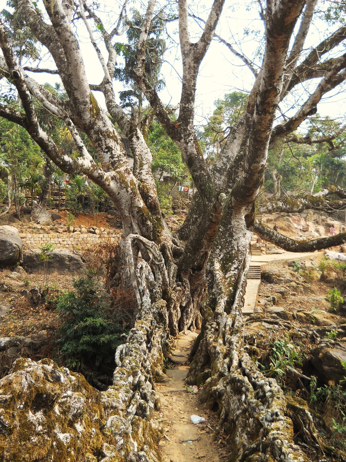
KUDENG RIM 3 (The Great Bridge of Kudeng Rim)
This bridge is part of one of the most spectacular views in all of Meghalaya. The bridge itself is a very long one, and actually consists of two spans, one after another (something which my camera was incapable of capturing without a wide angle lens). It's also noteworthy because it's one of the very few living root bridges that are a great distance above the streams they cross. None of the famous living root bridges in the Cherrapunji area are more than a few meters above their streams. I would estimate that the Great Bridge of Kudeng Rim is about 60-70 meters above the water (it's actually higher than these photos make it look!).
The setting for the living root bridge is also maybe the most incredible I've seen. It spans a straight-walled canyon, above a significant river. A short distance upstream, visible in the picture below (again, looking much smaller than it actually is), is a large waterfall with an incredible, blue-water plunge pool. It's possible in the dry season to cross the bridge, climb down into the river, clamber up the boulders to the plunge pool, and then swim to the base of waterfall....which also happens to create a rainbow when the sun hits the spray at the right angle. This spot alone has the potential to make Kudeng Rim world famous, and the folks at Cultural Pursuits seem to have come here a few times, though, again, information online is incredibly scarce.
There are, however, a couple of drawbacks. The first is that the bridge, though spectacular, is also dangerous. It's made from a large number of fairly thin roots, and a fall from it would prove fatal. The second is that the beauty of the bridge is rather marred by the fact that water pipes are being laid across it to supply Kudeng Rim. The first view one gets of the living root bridge, after hiking down from the village, is something of a disappointment, and one can only appreciate the true scale of the structure by climbing onto a stone shelf a short distance down canyon from the bridge.
A friend of mine from nearby was of the opinion that the bridge, because it was rather precarious, should be torn down. This would be a disastrous mistake. The pictures I have posted do not so it justice: If people simply knew about this living root bridge, it would draw visitors from all over the globe.

The Great Bridge of Kudeng Rim. The waterfall in the background is maybe thirty meters high. It's much farther away, and therefore much bigger, than this picture makes it look. This bridge also looks like it might have been damaged in the past, though it was not possible at the time I visited to find out anything about its history.

Looking way up at the span of the Great Bridge of Kudeng Rim

A view of the bridge from upstream, which gives one a better idea of what the canyon it spans is like. Unfortunately, the lighting conditions at the time were not optimal. There was no guarantee I would ever be able to come back, so I had no option but to take the photo practically staring into the sun. Note the way the tree on the left side of the living root bridge seems to be almost propped up by its roots. A good third of the living root bridge is actually to the left of that tree, though that part of the bridge is obscured in this picture.

This is the first view one gets of the living root bridge, which doesn't give one any sort of impression of how incredible the structure is. In fact, as I recall, one only realizes how high the bridge is once one is about halfway across it...not for anyone with a fear of heights, I'm afraid...
BURMA VILLAGE: 1 BRIDGE (Double span)
Burma is a Khasi village, on the opposite side of the Umngot from all of the other villages in this post. Nobody seems to know whether or not its name has anything to do with Myanmar. While it does not seem to have a high concentration of living root bridges, it does have a single, very beautiful example, right in the middle of the village. It is one of the prettiest Khasi settlements I've been to thus far.
BURMA DOUBLE BRIDGE:
This is another example of a twin span living root bridge. It runs across a canyon right in the middle of the village, so were you to find yourself in Burma, locating the bridge would be an easy task.

A kid crosses Burma bridge. The concrete pillar in the background is part of another, modern, bridge that has been built directly next to the living root structure, in order to replace it. I was informed by a member of the village council that Burma's local government has outlawed damaging the bridge in any way, though he might have just been telling me what I wanted to hear.

The twin spans of Burma Bridge. Notice how different the two sides are. They were apparently maintained by two separate people, who had slightly different styles. There seem to be many more young roots on the left side than on the right. Notice the houses in the background, and the children.

The view of Burma Bridge from upstream.
Coming soon: Part 2: Living Root Bridges of Pynursla
Part 3: Living Root Bridges of the Twelve Villages
Part 4: Living Root Ladders, and other uses for living architecture
No comments:
Post a Comment
Note: Only a member of this blog may post a comment.