
The view from Zabriskie Point, one of the iconic vistas of Death Valley National Park, just after dawn.
So, this is going to be about Death Valley National Park, which stretches over about 5,300 miles of the Mohave Desert in far eastern California (and a small patch western Nevada). The park encompasses not only Death Valley itself, but also a vast expanse of the Panimint and Last Chance ranges. The terrain is immensely varied, from Telescope Peak in the Panimints, which rises to 11'049 feet, to Badwater Basin, the lowest point in the U.S., and second lowest in the Western Hemisphere, which is 282 feet below sea level. The series of ranges and valleys within the park are part of the Basin and Range Provence, where, as with the Inyo Mountains to the west, whole blocks of the earth's have either been pushed up or caused to sink due to tectonic forces. One of the results of these processes are valleys, such as Death Valley itself, that are actually below sea level, and are apparently still sinking. Instead of seeking out a path to the ocean, the water courses in this region flow down into the middle of the sinks created by the extremely low lying valleys and empty into huge salt flats, such as Badwater Basin.
Death Valley is perhaps best known for simply being extremely hot and extremely dry. In fact, there is no hotter or drier place in the U.S.. Now, that all by itself doesn't make the place sound like all that great a vacation destination. However, what you rarely hear about is that the park contains an almost bewildering variety of landscapes, from high mountains, to multiple varieties of colorful badlands, to immense wide open valleys, to narrow canyons, to great big sand dunes, to volcano fields. Despite the fact that the park is so huge that my home state of Delaware could nearly fit inside of it, it still contains an incredible concentration of things to see.

Father Crowley Vista, looking west. This is in the very Westernmost part of the park, near
Panamint Springs. It's one of the first stops in the park if you're approaching from the west. The canyon is appropriately named Rainbow Canyon. The black material that makes up the uppermost layer is an old lava flow. Father John J. Crowley was a Catholic Priest who lived in the Owens Vallet/Death Valley region, where he had a small parish that served, among others, the CCC members who built the Whitney Portal Trail. He was known for celebrating the first mass on the top Mt. Whitney, and for writing a column, under the pen name "Inyokel" entitled: "Sage and Tumbleweed by Inyokel, some facts about the top of the United States and the Bottom, Death Valley and what lies in between!"
When me and my family drove into Death Valley, in the middle of October, the temperatures were still getting well up above 100 degrees, and after coming from the relatively salubrious climate of the Owens Valley, the waterless harsh hotness of Death Valley took a little getting used to. Our campground, called Texas Spring, was almost without any sort of shade at all. You just pitched your tents on the dry salty dirt. We had made a reservation in the Furnace Creek Campground, which was just across the road and looked like it had rather more bushes, but the camp was closed for renovations.
The area around Furnace Creek is an odd little enclave. Other than the national park facilities, there's a small Shoshone Indian reservation and a luxury resort, which includes "The World's Lowest Golf Course," along with swimming pools, horseback riding, and a "Borax Museum." Coming up on the resort after travelling though a hundred miles of godforsaken sun-blasted Mohave wilderness makes you feel like you've got something wrong with your brain.
As for the Shoshones, they're a group who are now recognized as the Death Valley Timbisha Shoshone Band, who evidently have a history in the valley going back over a thousand years. They live in Furnace Springs, in the Owens Valley, and over the border in Nevada, and are a part of the Western Shoshone group.

A large formation along the Golden Canyon Trail, just south of Furnace Creek. It was very hot. We wound up taking this hike right in the middle of the day, which in Death Valley, even in October, is brutal. The trail is appropriately named as the canyon is, truly, quite golden. This trail is part of a network that one can take up to (or down from) Zabriskie Point.

A view south from a ridge above the Red Cathedral, across the badlands below Zabriskie Point. These are composed of what is known as mudstone, which is very soft, unstable rock formed from sediments left behind by a lake that once filled Death Valley, back when the climate was wetter. The ground can't sustain any form of vegetation, and as a result erodes very quickly. Though major rainfalls are few and far between, when they do occur here they radically reshape the land.

More mudstone. This feature is much bigger than it looks.

A view on the Artists Palette Drive (and my shadow). The Artists Palette is an area of unusually bizarre badlands to the south of Golden Canyon. Again, this cliff face is much bigger than it looks in this picture, and that tooth past color on the rocks is not the result of photoshopping. The colors, as in so much of the American West, come from the oxidation of various substances, the green being Mica. The effect is rather more weird than it is beautiful, unlike Zabriskie Point. However, the area would probably look better a few hours after this photo was taken. As I remember, by the time we got here, everybody was feeling awfully sunblasted and dehydrated.

The Natural Bridge of Natural Bridge Canyon, which is a few miles south of the Artist Palette. The Canyon cuts deep into the Amargosa Range, which is the line of mountains that form the eastern boundary of the park. Up until this point, the canyon is composed of the same stuff as the badlands. To get an idea of the scale, that small pointy object under the center of the arch (which is actually a rock cairn), is about three feet tall. Also, if you look really carefully, you can see a couple of people rounding the bend up the canyon.

Deeper into the Amargosa Range, late in the afternoon, with sun still on the higher peaks. After the Natural Bridge, the canyon starts to transition out of the mudstone and into a different, harder, rock formation. At this point the canyon narrows. There is a short dryfall that you can climb over, though only a few minutes after that there's another, taller, dryfall that would require technical equipment to get over (safely, that is).

Later in the day, looking through the Natural Arch in the opposite direction, towards the peaks of the Amargosa Range.

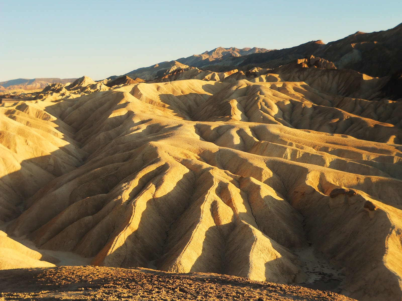
A Zabriskie Point sunrise, looking due west. This was one of the days where me and my sister Jeannie got up bright and early to go running around in the Badlands. The mountains in sunlight are the Panamints, and the base of them is about ten or twelve miles away from this point. It's hard to find color schemes that compare with those you see out west.

A trail marker at dawn, below Zabriskie Point. The mud-stone may erode quickly, but it's quite good to hike on. I've always noticed that in places like this, the tops of the ridges seem to have small paths warn into them, though they usually don't seem to be human-made hiking trails. I think that they're actually the tracks of small animals. As me and my sister saw later in the trip, these badlands are crawling with small mammals, including what's known as Kit Foxes. We saw a Kit Fox hiding in some rocks. It was grey and about the size of a cat. Unfortunately my pictures didn't turn out.
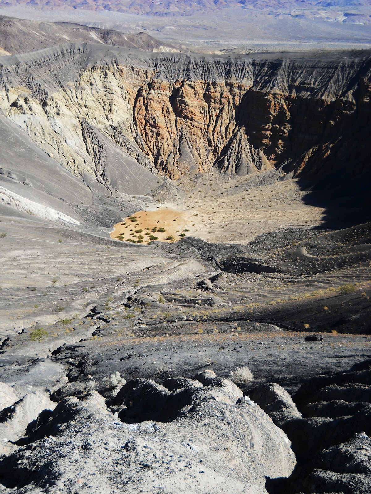
Ubehebe Crater, the central feature of a volcanic field about 50 miles north of Furnace Springs. Ubehebe, and most of the other, smaller, craters in the near vicinity were caused by magma rising and then heating up pockets of groundwater, the pressure from the resulting steam finally becoming so great that it burst up out of the bedrock. This particular type of volcano is known as a maar. Ubehebe seems to have erupted sometime in the last few thousand years. I've never seen a picture, including this one, which gave a proper impression of the incredible depth of this formation. I would say those bushes (which are actually small trees) are about 800 feet below. Also, for some reason, practically every photo of this thing makes it look much less steep than is actually is. It would be quite an adventure climbing down to the bottom of that thing and then back out.

The side of Ubehebe crater. The ground here is composed of crushed, blackened bits of cinder. One thing that surprised me about going out west was the amount of volcanic scenery there is out there. I had heard about things like Mount St. Helens, but I had no idea that you could see lava flows and volcanoes in places like Flagstaff Arizona, or in Death Valley, for that matter.

Little Hebe Crater, with the Last Chance Range in the distance. This crater is unique among the features in the Ubehebe Volcano Field, as it was not formed from a steam explosion. It's a much more typical variety of volcanic feature called a spatter cone. This is where lava has been erupting through a small vent in the ground and then falling back to earth around it, gradually building up around the central vent until it's formed the classic sloping volcano shape. That slope in the background is the western edge of another maar that formed before the main Ubehebe Crater did. Little Hebe developed right in the middle of the older crater.

Red cliffs on the Eastern edge of Ubehebe Crater. The red rock is the original bedrock in this area, which over time has become overlain with a layer of cinders from various eruptions. Ubehebe, by the way, means "A large basket in the rock" in the Timbisha Shoshone language.

Scotty's Castle, a weird enterprise in the gosforsaken desert. It was built in the 1920s as a vacation home by a millionaire from Chicago named Albert Johnson. He had been (seemingly) tricked into investing a huge sum in a (probably) fictional gold mine by a colorful Spirit of the Desert by the name of Walter Scott, A.K.A Death Valley Scotty. Scotty, after a lengthy stint in Buffallo Bill Cody's Wild West Show, started making a living as a con-man. His scam was to convince rich eastern millionaires to invest in nonexistent goldmines, and then live like a king off the money they gave him. When Johnson came out to see what was what, he saw that he was being ripped off, but he liked Death Valley so much he decided he had to build a big castle as a vacation home. He later forgave Scott, who then went and claimed that the Castle was, in fact, his. Go figure...Frankly, I think Death Valley just sort of drives people nuts. I wonder what the Shoshones were like....Anyway, the castle itself is really rather tacky, and after all of the vast natural awesomeness of Death Valley it's really quite a comedown. It is a good lunch spot though, as there's a small oasis. The national Park Service runs tours of the place, which figure tour guides who are dressed like 1920s gangsters. They were sort of milling around the parking lot in character. It's surreal.

Looking south down a side canyon in Fall Canyon, deep in the Grapevine Mountains. Fall Canyon is one watercourse north of the much more heavily visited Titus Canyon. Evidently after a certain point this canyon has some true, slot-canyon like narrows, though these were rather too far upstream for us to reach at the time we visited, which was at the tail end of a long day of explorations. Still, the lower portion of Fall Canyon is nothing to sneeze at. This side canyon was also an interested place to mess about.

One of the narrower sections of the lower end of Fall Canyon.

A Chuckwalla under a rock. Chuckwallas are the largest kind of lizard in this part of the world. The word Chuckwalla is also of Shoshone origin. I know from my dad and my sisters, who spent a bunch of time in the bottom of the Grand Canyon (which is apparently overrun with these guys), that when they want to get away from you they'll hide under a rock and then inflate their bodies, so that even if you get a hold of them they'll be wedged in so tight that you won't be able to pull them out...

....However, if the ground cover is loose enough, you can easily get at them by simply digging them out. I understand They can get much bigger than this.

Looking North from Dante's View, across Badwater Basin, around sunset. This was the best view that we had while in Death Valley. Dante's view is over a mile above Badwater Basin, on top of the Amargosa Range, and as a result is significantly cooler. The valley in this picture is about twelve miles wide. The region that looks like a huge lake is Badwater Basin, which is essentially just a huge salt pan, where water occasionally collects, but then rapidly evaporates. About 10'000 years ago, when the region was much wetter, the whole valley was covered with a huge inland sea called Lake Manly. There's a kind of fish, called the Death Valley Pupfish, which once lived in Lake Manly and today struggles on in a few small isolated salty sumps on the valley floor.

Looking Northeast from Dante's View.

And now due north.

The Sun setting behind Telescope Peak, the highest point in Death Valley. The distance from Badwater Basin to the top of Telescope Peak is the greatest vertical relief in the lower 48. The difference in elevation is over two miles straight down, or twice that of the deepest spots in the Grand Canyon.

Mosaic Canyon, which cuts into the Panamints around Stovepipe Wells village. When we were here, there were lots of people on the first ten minutes or so of the hike, but practically everyone chickened out or lost interest after that point. The first section has some interesting narrows, but then the canyon widens out, and is less interesting for a little while. I think that once most people hit this point they think there's no point continuing, when in fact, after only a short distance, the canyon narrows again, and is very much worth exploring.

A relativity narrow section. The white stuff is a kind of compressed metamorphic rock that has been sort of smoothed and polished over the years by grit dragged over it by flash floods.

The Mosaics of Mosaic Canyon. This stuff is known as Mosaic Breccia, and is the result of fragments of practically every variety of rock in the Panamints being cemented together.

More Mosaic Breccia.

In Titus Canyon, just south of Fall Canyon, which is easily accessible by car. Unlike Fall Canyon, Titus Canyon gets narrow almost immediately, though it apparently never turns into a true slot canyon as there is a road that travels the whole distance through it. This photo was taken late in the day, after climbing about 90 feet up to a ledge on the side of the canyon wall.

The walls of Titus Canyon, looking rather more like something you would see on the Colorado Plateau than in California. I would say those cliffs are at least a thousand feet high.

Deeper into Titus Canyon, later in the day.

Back at Zabriskie point, around sunset. I think this same picture has been taken about a billion times, but what the hell. It's still nice.
Here's another oft photographed spot. This was our last evening in Death Valley.

This is from Zabriskie point, though looking in the opposite direction.
In our three days in Death Valley, we saw a whole lot, but it was apparent that you could spend you whole life there and never run out of things to see. I would really like to see a Death Valley Pupfish, to climb Telescope Peak, or to be in the valley during the infrequent intervals when there's been enough rain that the salt pans briefly become lakes again...but, oh well, life's short.
No comments:
Post a Comment
Note: Only a member of this blog may post a comment.