
A particularly surreal patch of the American Southwest: One of the many caves in the vicinity of the Joint Trail, in the Needles District of Canyonlands National Park. Nope, it's got nothing to do with getting high. Sorry.
So, this is the last part of my write-up on the nine days me and my family spent in Utah in July. For the last two days of our trip, we stayed at Squaw Flat campground, which is in a separate unit of Canyonlands National Park called the Needles District. Despite being, as the crow flies, only a few miles from the Island in the sky District, the Needles area is completely unlike anything in Northern Canyonlands or in Arches National Park. Both the rock formations and the colors they come in are completely different, creating a place that is, at least as far as I can tell, absolutely unique on the face of the planet.
That being said, the Needles District is a rather more low-key sort of a place that Island in the Sky. In Island in the Sky, the prime attraction is giant, jaw-dropping vistas, that one would be hard pressed not to notice. By contrast, in the Needles you have to dig deeper, and work much harder, to get to the more amazing places that the area has to offer. Many of the most interesting things that I saw were buried deep in the back- country. Even though it's part of the same park, the contrast between the two districts is extreme. I wouldn't recommend it as a place to visit if you were pressed for time: You really have to go hiking out into it to get the full effect.
Our trip out there didn't begin under the best of circumstances. First, when we were packing up to leave Dead Horse Point, we overloaded the luggage racks on our SUV, so we lost two of our bags off the top of our car heading down route 191, one of which had half of our tents. Then, after we got down there, my dad noticed that he had lost his medication, which somebody had inadvertently thrown away, so he and my sister had to make the ninety minute drive back up to Island in the Sky to go dumpster diving....still, he found the meds...
Our campground was called Squaw Flats. It's a National Park Campground, and it's first come, first serve, which means, if you want a site, you have to get there pretty early in the morning. And it's popular even when we were there, which, in the middle of July, was certainly not the high season. We probably wouldn't have been able to bag a spot if we had arrived in the afternoon. There's absolutely nothing, at least in terms of civilization, in the near vicinity: I think it's close to 50 miles to Monticello, the nearest town. But it's a great campground. Each of the sites are next to rock formations, most of which have caves and overhangs that one can camp out under, which, for us at least, was good thing, given half our tents went M.I.A. somewhere between Moab and Hole in the Rock.
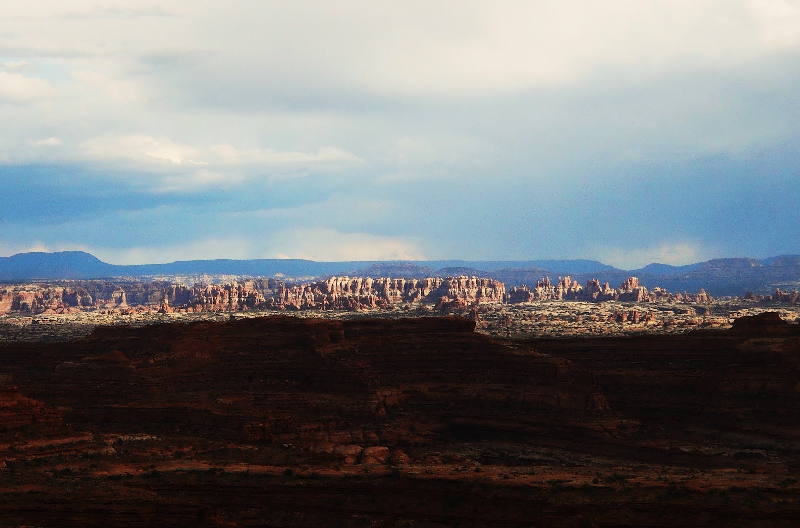
The Titular Needles of the Needles. Looking towards the Needles District from the White Crack, along the White Rim, with Monsoon storms building up over the Abajos. Our campsite was somewhere to the left side of this picture. The Needles themselves were about 8 miles away from where I took this picture, though I had the Colorado between me and them, which meant that in order to get to them one had to drive 90 miles.

Looking towards Island in the Sky from the Needles, near the beginning of the Chesler Park trail, close to sunset. This photo is the reverse of the last one.

The same view, now closer in, looking back towards the White Crack from the Needles. The larger Mesa is Island in the Sky, while Junction Butte is the smaller one to the left. You can also just make out, sticking out next to Junction Butte, Candlestick Tower, which is considerably further north. Below the two mesas you can see a horizontal white line: that's the White Rim Sandstone layer viewed dead on. The White Crack campground is somewhere along that line, below junction butte.

Needles, on the last full day of our trip, on our biggest hike (11 miles). Our objective was the Joint Trail, an area of deep, slot canyon-like fractures, just south of a place called Chesler Park. The variety of rock that makes up the actual needles of the Needles District is named Cedar Mesa Sandstone. The geologic explanation that I've heard for these features (which I find a little improbable in certain respects, but what the hell do I know) is this: In the Cedar Mesa Sandstone, you have two sets of fractures, one which is composed of north/south running cracks, and one that's made up of east/west trending cracks. The north/south trending fractures were caused by an uplift that raised the entire area, while the east/west running cracks were caused by subterranean salt deposits gradually flowing under the ground towards the Colorado, causing subsidence which ultimately fractured the Cedar Mesa Sandstone. The two sets of fractures intersect, and have carved the landscape into a sort of huge grid composed of giant sandstone squares, and as water flows down between them, it widens the fractures, eroding the stone blocks into the spires and pedestals that you can see today. At least, that's the theory...

Rock towers rising like the battlements of a ruined fortress. This is on the last stretch of the trail leading to one of the more famous parts of the Needles District, Chesler Park.

Rocks.

Rock Spires around the edge of Chesler Park. Chesler Park is a wide meadow, around a mile and a half across, ringed by some of the tallest rock spires in the whole of the Needles District. It's rather a peculiar place, and gives one the feeling of being on a sort of lost plateu hidden deep in the wilderness. There's a similar, remote, rock-tower-ringed meadow nearby called Virginia park which has precisely no trails or roads going out to it.

The wall around Chesler Park.

Stairs down into the Joint Trail proper. This is along the southern edge of Chesler Park. The trail leads you for about 20 minutes through a very narrow, north/south rock fracture, with a series of east/west fractures intersecting it. Once we got down those steps, I would say that the temperature dropped by at least ten degrees.

Through the joint trail, in an area that's very much like walking along the bottom of a slot canyon, only with straighter walls. As you proceed, the canyon walls get deeper and deeper.

Looking straight up.

Cairn Cave, the most famous and oft photographed section of the Joint Trail. I wonder how long that forest of cairns has been there, and who constructed the first one. Actually, I wonder if anybody knows.... I think that for most people who visit the Joint Trail, this is the turn around point. Geologically speaking, what's happening here seems to be that water comes down through a narrow crack in the erosion resistant rock above, but then finds the stone in the layer below easier to erode, cutting out something that's more like a fully enclosed cave than a canyon. One thing that I didn't realize researching this area on the internet is that the Cairn Cave is only one of many such features. You can see from this picture, looking through the opening of the cave and across the main canyon that it branches off from, the entrance to another cave, which is the continuation of the same east/west going fracture. The first photo in this post is from a different, less visited cave, only two or three minutes down canyon from this one. I'm not entirely sure what to call these features: they're actually something between caves and slot canyons. All of these chambers have narrow slits that run across the roof and allow water to flow in, meaning that the chambers aren't totally enclosed, and are in that respect kind of like slot canyons. On the other hand, the way that they tend to erode into wide dark tunnels gives them a rather different feel from being in classic slot canyons...I like the word "Alcove."...

A particularly fancy cairn in Cairn Cave. I don't know if Cairn Cave has an official title, but I have to call it something....

If I remember correctly, this cairn is in a little alcove that's at the end of the cave in the first picture of this post. Some of these caves have fairly extensive passages that go far back into the rock, and require a flashlight to explore.

Spectacular chamber. This is after the marked path takes you through Cairn Cave, and then down a short slope. The path makes a turn to the left, but ahead you can see the entrances to a couple of big alcoves (which are somewhat obscured by the trees you can see in this picture). The area directly below where the trail emerges from Cairn Cave contains an interconnected series of these chambers. Exploring them is something like going through a great big, extremely weird, maze. Unfortunately, I had only around ten minutes to climb around in this particular area (I was carrying everybody's lunch, so I had to return to the group pretty soon). But, if you ask me, this chamber is nearly as spectacular as the one that you usually see pictures of, but as far as I know nobody else has posted pictures of this particular chamber online.

Looking out through another alcove below Cairn Cave. I have seen one picture of this particular view online, posted by a certain John Kercher...As you can see, in this area the alcoves are quite huge. The process of erosion is evidently farther along around here.

My brother stares into the portal to another dimension. This particular alcove may not be quite as photogenic as Cairn Cave (this picture doesn't give you anything like a proper sense of scale), but, at least for my money, it was more interesting, and, as far as I can tell, practically nobody knows about it. This photo was taken on a ridge that was actually in the middle of this passage, which cut all the way through a huge, 200-300 foot across block of sandstone. I discovered this just sort of wandering around in the area near Cairn Cave.

A natural arch in the "Portal to Another Dimension" alcove. This is looking in the opposite direction from the last picture. I remember that, when I found this alcove, I had climbed all the way into the middle of it before I happened to turn around and see that it contained a spectacular natural arch. Unfortunately, I didn't have time to take a very good photo, but this at least gives you an idea. What seems to have happened here is that there were two fissures right next to each other, and as they widened out into full sized chambers, the wall of rock between them became progressively narrower, until it finally collapsed, linking the two chambers, though leaving behind the pillar of rock that you see here. Once again, the arch is much bigger than it looks in this picture.

The view through the arch. If you ask me, this particular alcove would be one of the main attractions of the Joint Trail if more people knew about it. One thing that became apparent travelling through this area was that, given the nature of the Cedar Mesa Sandstone Formation, the Needles must contain a huge number of these alcoves, most of which seem to be largely unknown (except, probably, by park employees). For example, I bet there are any number of Joint Trail-like places around Virginia Park, only they don't have hiking routes that lead to them. If you happen to be on the Joint Trail, this alcove is definitely worth a side trip. To get there, go past the point where the route takes you through the Cairn Cave, and continue along the bottom of the main canyon. Only a minute or so after the opening to Cairn Cave, you'll see a large, open, side canyon leading to your left. Take that, and after heading up the side-canyon for a few minutes, you'll come to the intersection with yet another canyon. Turn right, and the opening to the Portal To Another Dimension will be in the wall just a few minutes down the canyon.

Cave Spring. After finishing our 11 mile hike out to the Joint Trail, we hung about at our campsite for a while, before heading back out for a last bit of exploration. Cave Spring here, which we hadn't known anything at all about before we visited, turned out to be much more interesting than we were expecting. You can see that there's moss growing out of a crack in the wall in the background. That's where the spring of Cave Spring, one of the only year round sources of water in the area, flows out. Because of this, cowboys in the late 19th and early 20th centuries were able to establish a back-country camp here. They were the ones who blackened the roof with campfires.

Bird-Man Indian pictograph on the wall of Cave Spring. The cowboy's weren't the first people to stay here...

The last sunset of our trip, with bad weather beginning to move in. This view is west, from the end of the scenic road.

The weather getting worse. This is from a large rock formation above our campsite. We had a little canyon just behind where we had pitched our tents. You could climb up from this, and then to the top of the rock formation, so that you could get a view well out over southern Utah.

The last sunset over Squaw Flats. Again, the Monsoon may have made the trip a little wetter than I would have liked, and it certainly made the White Rim Road much more dangerous, but, on the other hand, it made for amazing skies. As I took this picture, a storm was building up behind me. I had to beat a hasty retreat off the top of the rock formation behind Squaw Flats as the lightening started up...

Our last night in Canyonlands was not peaceful: the storm built up on us and then it rained for about three hours straight. For the first twenty minutes or so, we hid under a large overhang that was behind our campsite, and hoped that we would be protected from the rain. For a while we remained dry, but slowly the rain advanced further and further into the overhang. This photo was taken with a flash while the rain was falling its hardest. You can see the fingers of water than were slowly getting further and further back into the overhang. Finally, the rain just got too hard, and we had to fall back to our car.

Campfire. Later that night. It was still cold and drizzling, but we decided to go ahead and have a big fire anyway. It seemed like the right way to end the trip. And it helped us dry out....The next morning, we started on the long journey back to Las-Vegas, and then to Baltimore by way of San-Francisco. And then, after 20 hours or so, we were back in....Delaware...yes.... Delaware....
So, that was Utah. Now, in less than 48 hours, I'll be heading back out to India, and will probably be posting on that by about mid November. Hopefully I'll have lots of pictures and plenty to write about!
Wish me Luck!

Your Farewell Lizard.....
No comments:
Post a Comment
Note: Only a member of this blog may post a comment.