
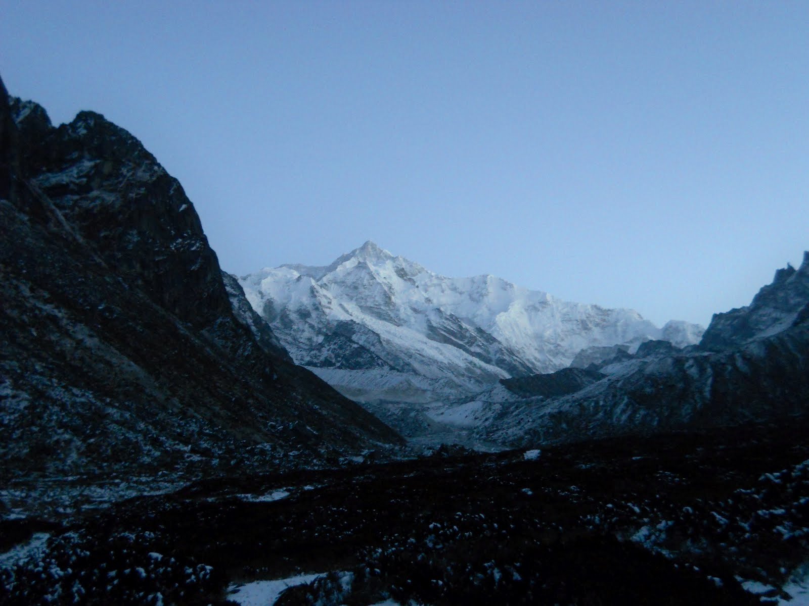
Postcard shot of Mt. Kanchenjunga (8586 m, 28,169 ft), the world's third tallest mountain, at about six in the morning. In the picture the peak doesn't look that far away, but that's an illusion. From where I took this, the peak is still roughly 15,000 feet higher. You just don't have vertical relief like that in the lower 48.
Hi there. So, I'm experimenting with putting the pics in a wider format. Please tell me if it looks weird!

My guides trudging through the snow, a couple hours out from Dzongri Meadows. We were the first people to have come so far this year. The large triangular peak to the left with the clouds streaming off it is Mt. Pandim, noticeably closer now than from Tsoka. In terms of morale, this was the low point of the trip. After leaving Dzongri, the trail plummets almost straight down about 1300 ft into the valley of the Prek Chu River over a very steep, and not very short, series of switchbacks. On a good day, going down these would make Walters Wiggles in Zion National Park (if that means anything to you), or the North Kaibab Trail in the Grand Canyon, seem like a walk in the park. But at the time, the trail was covered in ice and snow, with big drifts near the bottom a couple of feet deep. Getting yaks down that was no picnic, I'll tell you.

Pandim again, from the top of the switchbacks, with more clouds building up. Every day, each mountain seemed to sort of grow its own weather. That cloud would always be there by this time of day (around 8 AM), and once you saw it (or the corresponding clouds on the other high peaks) you knew that you only had, at most, another three hours or so before snow and fog would set in.

Yet another view of Pandim, this time from the valley of the Prek Chu, about one unpleasant hour later, after coming 1300ft down the switchbacks. The Prek Chu originates in the glacial wilderness at the base of Kanchenjunga.
This was, pound for pound, the most difficult day of the trek. Basically, since we were the first people to come so far, and since the weather had taken a turn for the worse, we weren't at all sure how far we would get, or if we would get stuck somewhere and have to turn around. It was already pretty much a forgone conclusion that we wouldn't reach the Goecha La. Getting there apparently involves negotiating a bunch of glacial moraine, which during this time of year would have been covered in snow and ice. Even in good weather, climbing around on what are essentially just giant piles of sharp, shifting, unstable stones, recently eroded off the sides of the world's greatest rock faces, is dangerous and nerve racking. Doing the same with the rocks covered in snow would just be, well, stupid. Maybe if we had had safety ropes and crampons it might have been possible, but we didn't. However, my guide Bicheung told me that there was a viewpoint at about 15000 ft that we might still be able to reach. But that day it didn't seem likely that we would even make it that far. After we made it to our next campsite at Thangshing, if there was another night of weather as bad as the night before, we wouldn't have any choice but to turn around.
And most of the expedition wasn't happy about being there, either. Particularly Rahul, the Gum-booted Nepali Yak-Driver. I couldn't quite tell what he was saying, but he was complaining every slippery step of the way down the switch backs. I'm pretty sure he and Bicheung were arguing as to whether we should turn around, with Bicheung being the one who was for moving on. Actually, everyone, myself included, was in a right awful mood. Dragging yaks down the side of an icy mountain, in the thin air, miles and miles from any other human beings, just doesn't bring out the best in people. I got the distinct impression that everyone just wanted to go home, and, frankly, I could see where they were coming from.
One interesting thing that Bicheung and Rahul did on the way down was, whenever we came to an especially slippery spot, they would rip a piece of moss off the side of a tree, and then place it on the ice, I think to melt it for the next group that came that way (which, incidentally, wouldn't come for another three days.) I'm not exactly sure how efficacious it was, but I wouldn't be surprised if it made the way down for the next group easier.
Anyway, after the trail reaches the river, it crosses the snow covered rocks strewn across the bed, and then follows the right bank steeply up again for some time. At the bottom of the valley, you reenter Rhododendron forests for a short while, though after only around an hour of so after heading back uphill, the trees are stunted again, and the air is nearly as thin as it is in Dzongri.

Full blooded wild yaks who hung out around our next campsite in Thangshing. These guys are the descendants of Yaks the Tibetan refugees who lived below at Tsoka used to own. They set them free after Kanchenjunga National Park was established. Wild yaks have been roaming in these parts ever since. Actually, even though Yaks usually seem kind of funny, Bicheung informed me that it was dangerous even to go near these guys, and I believe him. Whenever I was around this fellow looking at the camera, he would always stop what he was doing and watch me. I was told that this herd used to have a baby, but that it disappeared a few months back, probably picked off by a snow leopard. Later on, me and Bicheung saw leopard prints in the snow, only a few miles away from this campsite (I would have taken a picture, but my camera was malfunctioning because of the cold).

Pandim in the cold and grey. It's just like they always say: In the Himalayas, if you don't like the weather, just wait ten minutes. It'll get worse.

Our camp at Thangshing. There are huts here, but they were destroyed by the earthquake, except for one, which was locked. Our tents were pitched on the edge of a little swamp, which would freeze solid at night, thaw in the morning, and then, after the clouds moved back in at around 10 am, slowly refreeze. The ground under my tent was always soft during the day, and by laying down I would create a human shaped indentation in the dirt.
That was the night that me and Bicheung decided to try to at least get as far as the viewpoint.That involved waking up at 3a.m. and walking for seven hours. I went to bed just after dark, which is I always did. There really wasn't anything to do at night other than hunker down in my sleeping bag and try and fend off the ever present cold....you really didn't want to do anything else.
During the night the temperature truly plummeted. Even during the coldest part of the day, usually the temperature wasn't that far below freezing. And in the mornings, with the sun blazing down on you with practically no atmosphere between you and it, it was downright hot (in a surface of the moon sort of way). But at night the cold was brutal. I would always have a water bottle with me in my tent when I went to sleep. In the morning, it would be a solid block of ice, and it was much warmer inside the tent than out. It makes me wonder what it's like dealing with the cold at truly high altitudes. It was a good thing I had two sleeping bags and could get relatively warm, at least when I was totally cocooned in them without practically any exposure to the outside air.
Needless to say, getting up in the morning was a bitch.
The first view of Kanchenjunga, before sunrise. Me and Bicheung managed to get up on time and head out around 3:45. However, the cold nearly killed my camera. It kept saying the battery was almost dead, that is, when it would turn on at all, and this was after I switched batteries only the night before. The only way I could get it to work was to put it inside my coat to warm it up. Then I could usually get one or two pictures out of it before it died again.

Two unknown peaks, on the way to viewpoint.
Other than my camera acting funny, the trip up to the viewpoint, except for one short section, wasn't all that difficult. Despite going up to about 15,000 feet, the altitude wasn't affecting me that much, and for the most part the path followed the right bank of the river, only rising gradually. It was only in the last third or so, after it began to climb up onto the moraine left behind by the retreat of the Zemathang Glacier at the base of Kanchenjunga, that it got a little strenuous. There's another campsite at this point, with huts, though they were destroyed at the time. It's next to small lake called Samiti, which was frozen solid. That was where we saw leopard tracks. They were obviously quite fresh, too, since it had snowed a little the day before, but the tracks weren't filled in at all.

Bicheung negotiating the one truly hairy part of the trek. The peak of Kanchenjunga is that perfectly triangular point in the upper left-hand portion of the photo. By this point, we had climbed up about 700 feet onto the moraine above Samiti lake. Here, the trail takes you up onto a huge rocky slope that rises up from the debris-blanketed Zemathang Glacier. For a few hundred feet or so you have to cut upwards and diagonally across the slope until you come out onto a small plateau. During this portion of the hike, you're totally exposed, with a drop of maybe five hundred feet down to the glacier below, and you have to sort of cling to the side of the slope. Without snow, it probably wouldn't have been much of a problem, but as it was, it demonstrated why we wouldn't have been able to get all the way to the Goecha La without crampons and safety rope. The whole rest of the trek apparently would have been over similar terrain. Oh well.

The view of Kanchenjunga, from the view point, with the utterly lifeless Zemathang glacier still in darkness...that's one thing about being in these sorts of places: There's a notable absence of any sort of living thing. Truly high mountain regions make Death Valley seem positively luxuriant.

Looking west, to a side glacier that feeds into the Zemathang, and the two peaks I had seen earlier, though from about 2000 feet above. The whole area from Samiti lake up is just a huge amphitheater of giant mountains.

Bicheung marking that we were indeed the first people this year to reach this spot, less than a month and a half ago. It feels like ages ago.

Slightly different view out across the glacier.

Looking south from the viewpoint. I think that pointy peak covered in ice may be Mt. Narsing (19030 ft).
After reaching the viewpoint, the sun came up quickly, and suddenly it was damn hot. The climate up in these regions is reliably extreme. You have to be prepared for every contingency. On this particular day, in the space of only ten hours or so, it went from well below zero before sunrise, to what felt like around 80 degrees by 8 A.M., to back down around freezing once the clouds moved in. And there's practically no transition between hot and cold: When the sun's out, it's immediately hot, and when a cloud passes in front of it, it's cold.
Anyway, we beat a hasty retreat back to camp, knowing that, with such a bright and sunny morning, the atmosphere would have lots of energy to charge up for the lousy weather that would invariably move in later in the day. As we walked along, we began to hear rockfalls down on the moraine. That's another thing you get up in these parts. The terrain on and around the glaciers, being extremely recent and unstable, is constantly shifting, and you can actually see it changing right in front of you. During the night, the stones in the moraines are cemented in place by frozen water, but once that water starts to melt during the course of the day, the stones shift, and sometimes tumble out of the sides of slopes, creating rockfalls. As me and Bicheung were walking back, and the day got warmer and warmer, we heard more and more of these. Also, as we passed back by Samiti lake, we heard it loudly snapping and popping as the ice over the surface of the lake began to melt.

Looking up at Pandim from near Samiti Lake.

Close up on the hanging glaciers in a saddle next to Pandim. I think that for most people, their mental image of Glaciers is more like these than the Zemathang glacier. But in the Himalayas, most of the truly huge glaciers (like the Gangotri glacier in Uttarakhand, or the Baltoro glacier in Pakistan), flow down through valleys between the peaks and so wind up covered in a crust of debris eroded off the rock faces, which often look black from a distance. Hence the name "Black Glacier."

Just more Pandim.
We got back at around 10 that day, and almost immediately afterwords, bad weather moved in and we didn't see the mountains again until the next morning. It snowed lightly the rest of the day. I can honesty say I did nothing but read all the way to dinner.

Preparing to start the long trek back down. Bicheung is the one looking into the camera. Those buildings in the background are the partially destroyed campsite at Thangshing.

Big mountains.....
Of all the days on the trek, the most physically tough was the hike from Thangshing at around 13000 ft, all the way down to Bakhim, at 9000 feet. This required about ten hours walking, a good portion of it uphill, all the way back to Dzongri, and then down below Tsoka. The same switchbacks that we had to struggle down a few days before, we now had to struggle back up, and though this was by no means the highest part of the trip, it was the steepest. Whats more, we wound up going uphill during the hottest part of the day, before the clouds moved in.
After that, we reached Dzondri, and then headed straight down, into thick air and life. It's such a relief heading down and knowing that you don't have to go back up again.

Back to the world of the living. Rhododendron trees at around 11000 feet. With every step down, the air became easier to breath, and the plants looked less desperate.

White Rhododendrons, at around 9000 ft, near Bakhim. This was after reaching our objective for the day. I remember it being such a relief to be able to wear sandals.

Not a great picture, but you can see both White and Red Rhododendrons. I have been told that there are five different varieties of Rhododendron in Sikkim. The species is Rhododendron arboreum, which only grows in South and Southeast Asia.

Walking down the next day, in the even thicker air.

Looking across the valley of the lower Prek Chu at Earthquake damage. The zigzags to the right of the picture are the trail, and you can just barely make out our four yaks making their way back up. That should give you some sense of the scale of the disaster. This particular landslide cut off a large portion of the trial. The switchbacks are newly built. The state government was tasked not only with building a new trail, but also with providing it with a stone border. The builders evidently took the money, but never built the border. Apparently the government is also allocated lots of money to work on the trekkers huts, but rarely ever actually deliver anything.

Bridge crossing the Prek Chu.

Big damn white Rhododendron. I would say that this bloom was about the size of my head!

Yak-Jam. As we were coming back, there was another group (usually much bigger than ours) every few minutes. Some of them had up to twenty yaks. It was a mess.

The bridge out of the Park.
Well, that's all for now.....
No comments:
Post a Comment
Note: Only a member of this blog may post a comment.